Magnetic north, true north, and grid north explained
Three different norths, and the corrections between them. What declination is, why it moves, and when the difference actually matters.
7 min read · updated
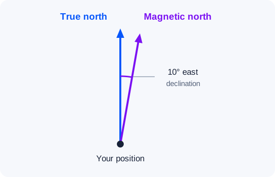
Ask three instruments where north is and you get three different answers. They are all correct; they are answering slightly different questions.
Use the magnetic declination calculator to find the local correction. For a practical bearing example, see magnetic versus true north for Qibla.
The three norths
True north
The direction of the geographic North Pole, the point the Earth actually spins around. Lines of longitude converge on it. This is the north that maps, satellite imagery, and GPS bearings use.
Magnetic north
The direction a compass needle points. It follows the Earth's magnetic field, which is generated by convection in the liquid outer core and is neither aligned with the spin axis nor stable. The magnetic north pole has been wandering north across the Arctic for decades and has recently been moving at tens of kilometres per year.
Grid north
The direction the vertical grid lines run on a projected map. Because a curved Earth cannot be flattened without distortion, grid lines only align with true north along the projection's central meridian; elsewhere they lean by a small angle called convergence, typically under two degrees on national mapping.
Declination is the correction you actually use
Magnetic declination, which mariners call variation, is the angle between magnetic north and true north at a given place and time. It is stated as east or west:
- East declination means the needle points east of true north. Add it to a magnetic bearing to get a true bearing.
- West declination means the needle points west of true north. Subtract it.
The rhyme is east is least, west is best: subtract east declination when going from true to magnetic, add west. Working the other way, from magnetic to true, flips it: add east, subtract west. If you find the mnemonics more confusing than the arithmetic, ignore them and reason it out from a sketch each time.
How big is it where you are?
It varies enormously. Across most of Europe declination is currently a couple of degrees; in parts of Alaska and eastern Canada it exceeds twenty degrees; near the magnetic poles it becomes meaningless because the horizontal field almost vanishes. There is a line, the agonic line, where declination is exactly zero, and it has been sweeping westward across North America.
Because it moves, a declination figure printed on an old map is not the figure you should be using. Values drift by roughly a tenth of a degree per year in stable regions and much faster near the poles. Anything more than a decade old deserves rechecking.
Where the numbers come from
Declination is not measured by your phone. It is predicted by a global model, the World Magnetic Model, produced jointly by NOAA/NCEI and the British Geological Survey and reissued every five years. The model represents the field as a sum of spherical harmonics up to degree twelve, with a linear rate of change per coefficient so it can be evaluated for any date inside its five-year window.
This site evaluates that model directly in your browser using the published coefficients, so declination figures are computed locally and work offline. The implementation is checked against NOAA's official test values.
When does the difference matter?
Use the one-in-sixty rule: one degree of error costs about one unit of sideways drift per sixty units travelled.
- Walking 500 m to a visible gate with 3° of declination? The error is 25 m and you will see the gate anyway. Ignore it.
- Crossing 8 km of featureless moorland with 15° of declination? The error is 2 km. Ignoring it would be dangerous.
- Aligning a solar panel, a satellite dish, or a building? Always correct, because these are stated in true bearings.
The practical workflow
- Look up declination for your position and today's date.
- Decide which frame your source bearing is in. Map bearings are true or grid; compass bearings are magnetic.
- Convert once, write down the converted number, and navigate with that.
The last step is the one that prevents errors. Converting repeatedly in the field, in wind, with cold hands, is how people apply the correction twice or in the wrong direction. That is an easy way to end up twice the declination off course.
Enter your position and date in the declination calculator before converting a magnetic bearing.
Frequently asked questions
What is the difference between magnetic and true north?
True north points toward the geographic North Pole. Magnetic north follows the local horizontal magnetic field, and the angle between them is magnetic declination.
Does magnetic declination change?
Yes. Declination varies by location and changes over time as Earth's magnetic field changes. Check a current model for the place and date you need.
When should I correct a compass bearing?
Correct it when you compare a magnetic compass reading with a true-north map or direction, especially over longer distances or where local declination is substantial.